
SkyTruth: Using Satellites to Protect the Planet
By AdministratorSkyTruth uses satellite imagery and other technology to protect the environment. They identify and monitor threats in order to make environmental concerns more visible and motivate people to take action to protect the planet. Skytruth’s innovative use of federal data and satellite imagery gives activists and legislators what they need to enforce existing laws and argue for more sustainable policies. At the same time, SkyTruth is creating new activists and citizen scientists by inviting the public to help monitor satellite images of fracking, illegal fishing, and drilling sites around the world.
SkyTruth’s imaging and sensory systems help discover bilge dumps and illegal commercial fishing in order to promote sustainable fishing. In just one example, SkyTruth’s involvement in an effort to curb illegal fishing off the Madagascar coast led not only to the capture of boats that were engaged in illegal fishing, but also the release of crew that had been enslaved on the fishing vessels. SkyTruth’s images documented a fishing vessel in a poorly monitored and remote location tied to several other boats, which proved, with corroborating evidence, that the boats were transferring illegally caught fish that were mixed with legal fish and taken to shore.
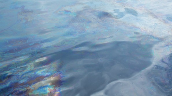
SkyTruth’s work has been pivotal in monitoring the oil and natural gas industry. In the U.S., data and imagery from SkyTruth has shown the devastating effects of Mountaintop Removal Mining.
![]() Off the coast of Brazil, SkyTruth’s satellite imagery has had a huge impact on both awareness in Brazil and regulation and enforcement of off-shore oil drilling in their waters. Following a report of a small oil leak in the seafloor that Chevron explained as a natural leak, SkyTruth reviewed satellite images and saw an oil slick that, at 56 miles long, if actually natural, would be the largest natural leak seen on satellite images and that didn’t exist before exploratory drilling started in the area. Following international coverage of the leak that lead to outcry in Brazil, Chevron admitted they’d lost control of a well. As a direct result of SkyTruth’s work, Chevron was banned from drilling in Brazil for some time, had to pay millions in fines and court settlements, and Brazil’s regulation and enforcement of offshore drilling has become more robust.
Off the coast of Brazil, SkyTruth’s satellite imagery has had a huge impact on both awareness in Brazil and regulation and enforcement of off-shore oil drilling in their waters. Following a report of a small oil leak in the seafloor that Chevron explained as a natural leak, SkyTruth reviewed satellite images and saw an oil slick that, at 56 miles long, if actually natural, would be the largest natural leak seen on satellite images and that didn’t exist before exploratory drilling started in the area. Following international coverage of the leak that lead to outcry in Brazil, Chevron admitted they’d lost control of a well. As a direct result of SkyTruth’s work, Chevron was banned from drilling in Brazil for some time, had to pay millions in fines and court settlements, and Brazil’s regulation and enforcement of offshore drilling has become more robust.
A SkyTruth motto is: “If you can see it, you can change it.” Using tools like satellite imaging, other long-distance sensors, and volunteers, SkyTruth is working to make sure we can see as many threats to the planets as possible in order to be able to stop them.
To stay informed about SkyTruth's programs and impacts, you can follow them on Facebook, or follow their blog.
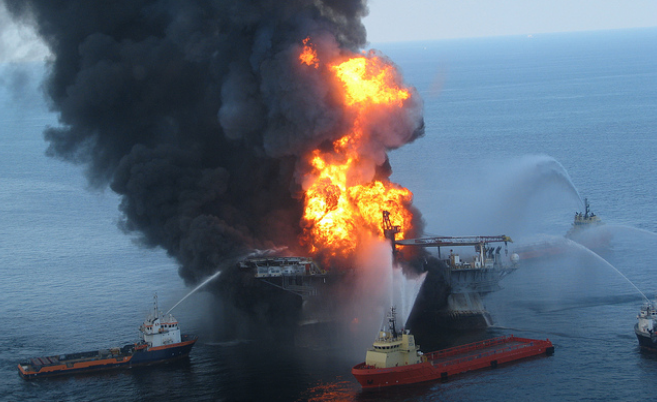
Featured photo is an aerial image obtained by SkyTruth immediately after the Deepwater Horizon oil spill in 2010.