
SkyTruth gives new view in the fight for the environment
By AdministratorThe uncertain future of the coal industry has been a central figure in the media’s portrayal of the political turmoil disrupting a large swath of the United States. So too has the uncertain future of environmental policy that protects the land in coal-rich regions. It’s never been more important to be able to take a literal step back and get a comprehensive view of the issues. By stepping way back, satellite-distance back, in fact, we are revealing the devastation left in the wake of the most destructive form of mining. This bird's eye view is also pointing the way toward a solution.
SkyTruth uses satellite and aerial imagery to study and reveal the marks humans are leaving on the earth in their ever-expanding quest for natural resources. We have shown the impacts of natural gas drilling on the Rocky Mountain west and the growth of strip mining throughout the United States. Our FrackFinder project has enlisted citizen scientists to help analyze tens of thousands of aerial images and build datasets on natural gas fracking sites that can be used to study impacts on public health and the environment.
Our reach has been both global and intimately local. Based in the foothills of the Appalachian Mountains in the small village of Shepherdstown, West Virginia, we have been conducting satellite image analyses on the environmental impact of Mountaintop Removal Mining (MTR) in these mountains since 2007. That work has changed policy, driven scientific research, and brought previously unrecognized destruction into the public eye.
“Apocalyptic transformation of Appalachia is happening under everybody’s nose,” says SkyTruth’s president and founder, John Amos, “and nobody can see it or realize it, until you get up in the air, and take a look and see how inexorably this destruction has grown over the last few decades. It really slaps you in the face.”
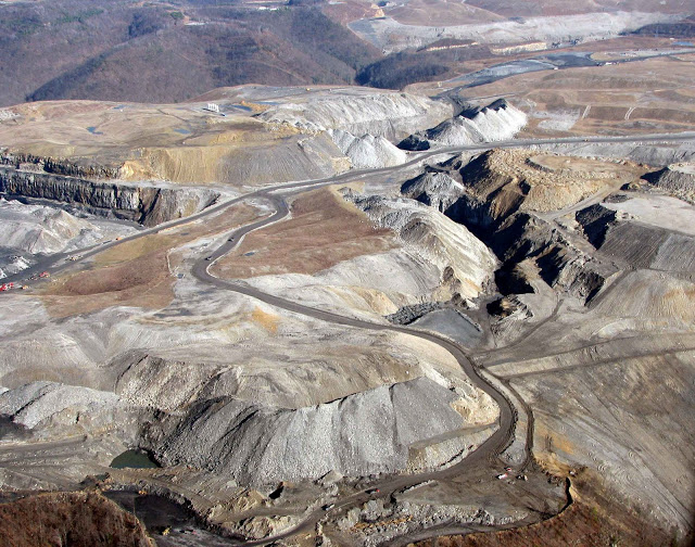 Mountaintop Removal mining involves blasting away mountain ridge tops to expose coal seams for extraction. Once the seam is exhausted, coal companies dump the “spoil” (the unusable earth that remains) into the valleys below, fouling waterways and poisoning sources of drinking water. When we began analyzing satellite images of the Appalachian Mountains ten years ago, no one—not even government officials charged with overseeing the mining industry—had a reliable map of where coal companies were conducting MTR or how many mountaintops had already been leveled.
Environmental groups had been sounding the alarm, and Appalachian Voices asked us if we could measure the extent of the destruction in West Virginia. John surveyed the satellite data. His shocking results provided the visceral impact that moved the political machine.
That original work covered 59 counties and identified nearly half a million acres of new mining over a 30-year period. SkyTruth’s data allowed outside organizations and research institutions to directly link MTR to downstream water pollution and related environmental and health effects. Some of the work is currently factoring in an unprecedented legal case between the EPA and the Army Corps of Engineers over mine permits.
This year, we have expanded our surveys to 74 counties in Kentucky, West Virginia, Tennessee and Virginia. Together with Duke University and Appalachian Voices, we have created an interactive, online mapping tool that displays a timeline of active mining from 1985 through 2015. “We are now taking the new tools that have become available to us through Google’s cloud computing infrastructure and the entire multi-million image archive of satellite data that is at our fingertips, and we are keeping people updated on year-to-year changes in the landscape,” John says.
Our motto is “If You Can See It, You Can Change It,” and the new map visualization tool allows everyone to see it. The map provides gut-wrenching visual evidence of the sheer scale of MTR across the Appalachians. Although it is unlikely that mountaintop removal will stop in the near future, understanding what the landscape looks like now, and what it looked like before can drive efforts to reclaim the land to a healthy, biodiverse ecosystem again. “It’s time to start thinking about transition,” John says.
SkyTruth’s work reveals the extent of the reclamation problem as the threat of coal company bankruptcies looms over Appalachia. Citizens will need diligence and evidence to ensure the courts hold companies to their commitments to repair the landscape they’ve so carelessly destroyed. But our birds-eye view also reveals the massive opportunity for economic revitalization in the region.
“Lots of people are going to have to drive lots of trucks and bulldozers and backhoes and plant trees, to reclaim this land,” says John. “That’s a lot of jobs that could help soften the blow from the continuing decline of mining in the region.” It may even be feasible to bring in outside dollars through the sale of carbon credits for forest planting. John hopes the new map SkyTruth is producing can become a springboard for that kind of thinking. “People need to be planning out what they want Appalachia to be in the future and how to get from here to there,” he says, underscoring SkyTruth’s unique ability to use images from the past and the present as tools to imagine the future.
Post has been supplied by SkyTruth.